Geography in Sri Lanka

Top tour packages
 3 Nights / 4 Days
Colombo with Bentota
Bentota (2N) Colombo (1N),
Flight Not Included
₹25,000
per person
- Valid upto 31 Oct 2025
 5 Nights / 6 Days
Sri Lanka Nature Tour
Kandy (2N) Nuwara Eliya (2N), +1 more
Flight Not Included
₹28,450
per person
- Valid upto 31 Oct 2025
 5 Nights / 6 Days
Beaches & Hills of Sri Lanka
Bentota (2N) Nuwara Eliya (2N), +1 more
Flight Not Included
₹32,760
per person
- Valid upto 31 Oct 2025
 8 Nights / 9 Days
Historical Sri Lanka
Dambulla (2N) Kandy (1N), +3 more
Flight Not Included
₹38,800
per person
- Valid upto 31 Oct 2025
 7 Nights / 8 Days
Scenic Sri Lanka
Kandy (2N) Nuwara Eliya (2N), +2 more
Flight Not Included
₹38,800
per person
- Valid upto 31 Oct 2025
 6 Nights / 7 Days
Explore The Un Explore - Sri Lanka
Dambulla (1N) Trincomalee (2N), +3 more
Flight Not Included
₹44,830
per person
- Valid upto 31 Oct 2025
 7 Nights / 8 Days
Scenic Sri Lanka – Chef Assisted Tour
Colombo (1N) Kandy (2N), +2 more
Main Flight Included
₹1,08,500
per person
- Oct
Happy Travellers
Incredible Europe Tour with Flamingo Transworld
Ms. Jyoti & Mr. Tushar
 Jul
JulWonderful Japan Trip Experience with Flamingo
Surabhi Udeshi
 May
MayUnforgettable Experience With Flamingo Transworld
Mr. Ambrish Shah
 Mar
MarAn Unforgettable Journey with Unnati and Flamingo !
Mr. Navneet Bisani
 Dec
DecWe are Thankful to Flamingo Tours And Travels
Mr. Vijay Shah
 Oct
OctExcellent Experience Southeast Trip With Flamingo Travels
Mr. Manoj Betai
 Jun
JunWonderful Trip with Flamingo Travels
Ms. Chetna Ajmera
 Jul
JulSuper Experience with Flamingo Travels
Shailesh Shah
 Jun
JunHappy and Satisfied a Dubai trip with Flamingo Travels
Rana Gaurang
 May
MayWe had a very good experience
Ms. Aishwarya Satav
 Jun
JunTrending travel articles

7-Day Bali Itinerary 2025: A First-Timer’s Travel Blueprint!
Summary: 7-Day Bali Itinerary – Planning your first trip to Bali? This blog offers a smart, practical, and exciting 7-day plan that includes everything you love – temples, beaches, shopping, and more. Bali, the Island of the Gods, is one of the favourite destinations for Indian tourists. Bali has a mix of beautiful nature, culture, […]

A First-Timer’s Guide to Dreamworld Queensland: What to Expect in 2025!
Summary: Dreamworld Queensland – Planning your trip to Dreamworld on the Gold Coast in 2025? This guide has everything you need! Discover how to get there, choose tickets, explore thrilling rides, meet Aussie animals, find yummy food, and get top tips for an amazing and memorable Australian adventure. Make your Dreamworld visit smooth, fun, and […]

Yas Island Abu Dhabi 2025: Ultimate Guide to Theme Parks, Events & New Attractions
Ready for the vacation of a lifetime? Yas Island Abu Dhabi is calling your name! Yas Island is the most iconic place for fun and thrill in the UAE. The island is only 20 minutes from Abu Dhabi and around 50 minutes from Dubai. This incredible 25 sq km island welcomed over 38 million visitors […]
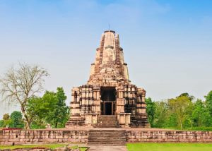
Khajuraho Temples Travel Guide 2025: Myths, Marvels & Must-Sees
Holidays are just around the corner, and you are thinking about where to go next and looking at Madhya Pradesh tour packages. Well, then, Khajuraho Temples should be at the top of your list. When you think of the Khajuraho Temples, you may imagine intricate sculptures and perhaps the famous erotic carvings. But Khajuraho is […]
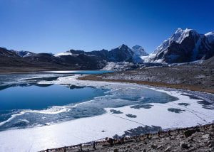
Why Gurudongmar Lake Should Be on Your 2025 Travel List!
Gurudongmar Lake – Northeast India is one of those places that feels far away and dreamy – everyone wants to go, but not many make it there. There is something undeniably magical about travelling through Northeast India – a region where every turn surprises you with misty hills, prayer flags, quiet monasteries, and raw natural […]

The 7 Best Waterfalls In India You Can’t-Miss In 2025!
There is something magical about waterfalls that grabs your attention. The sound of rushing water, the cool mist on your face, the sheer power of nature on display – it is truly special. I have spent years exploring the diverse landscapes in India, and trust me, the waterfalls in India are absolutely incredible. From massive […]

Best Indian Restaurants in Switzerland for 2025 Travellers!
Indian Restaurants in Switzerland – Imagine walking through the stunning Swiss Alps, taking photos of snowy mountains, or enjoying the lovely streets of Zurich. The air is fresh, the feeling is peaceful, and you love every minute of your trip. But after all that walking, sightseeing, and maybe even trying some yodelling, you start to […]

A Complete Travel Guide To Hoi An 2025 – Vietnam’s Most Charming Town
Hi – today let us explore a country in Southeast Asia. An incredible region that offers a classic mix of exciting discoveries and familiar comfort. Right in the heart of this region is Vietnam – a country with spectacular scenery, rich history, and delicious local food. Vietnam is full of contrasts. Ha Long Bay offers […]
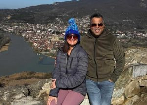
Georgia and Azerbaijan: A Trip Full Of Nature, Adventures & Us Time
You know that feeling when your home suddenly becomes too quiet? That is what happened when my daughter got married last year. Deep within, as a mother, there is a quiet shift – something changes. The house feels bigger and quieter. Evenings stretch longer. There is love all around, yet a little emptiness sits with […]

Winter in New Zealand 2025 – A Magical Experience You Shouldn’t Miss
Imagine a world where winter is not something to deal with but something to enjoy. With its varied landscapes, New Zealand presents a winter you will not forget. This stunning country turns into a peaceful winter wonderland with snow-covered mountains, crystal-clear lakes, cosy towns, and loads of fun things to do. Imagine standing in a […]