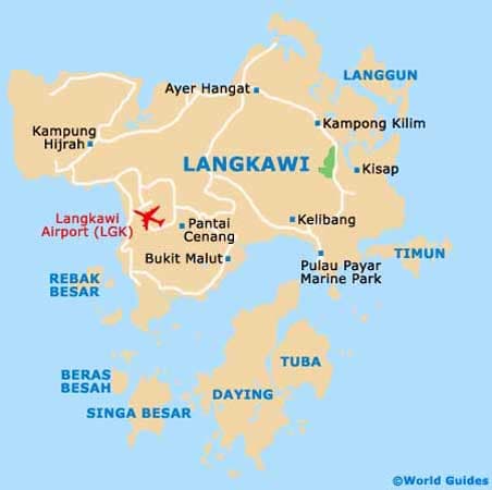
Geography in Langkawi
Top Tour Packages

Singapore With Malaysia Escape Tour
Kuala Lumpur (3N), Singapore (3N)
Main Flight Included
₹1,45,040
per person- Jan
- Sep

Escape Singapore and Malaysia
Kuala Lumpur (1N), Genting Highlands (1N), Kuala Lumpur (1N), Singapore (3N)
Main Flight Included
₹1,46,620
per person- Nov

Exciting Kuala Lumpur - Indian Group Tour
Kuala Lumpur (4N)
Flight Not Included
₹28,680
per person- Aug
- Dec
- Feb
- Jan
- Mar
- Nov
- Oct
- Sep
-1.jpg&w=1920&q=75)
Spellbinding Singapore & Malaysia - Indian Group Tour
Singapore (4N), Kuala Lumpur (2N)
Flight Not Included
₹89,400
per person- Aug
- Dec
- Feb
- Jan
- Mar
- Nov
- Oct
- Sep

Southeast Escape 1 with 2 Nights Cruise Tour
Singapore (3N), Cruise (2N), Kuala Lumpur (3N)
Main Flight Included
₹1,51,120
per person- Aug
- Dec
- Feb
- Jan
- Nov

Southeast Escape with 2 Nights Cruise
Kuala Lumpur (3N), Cruise (2N), Singapore (3N)
Main Flight Included
₹1,59,290
per person- Dec
- Oct
- Sep

South East Discovery Singapore Malaysia With Cruise
Singapore (3N), Cruise (2N), Kuala Lumpur (3N)
Main Flight Included
₹1,69,250
per person- Dec
- Jan
- Mar
- Nov
- Oct

South East Eminence Singapore Malaysia With Cruise
Singapore (2N), Cruise (2N), Singapore (1N), Kuala Lumpur (1N), Genting Highlands (1N), Kuala Lumpur (1N)
Main Flight Included
₹1,76,520
per person- Aug
- Dec
- Jan
- Mar
- Nov
- Sep
Experience Singapore Malaysia with Cruise
Singapore (2N), Cruise (2N), Singapore (1N), Kuala Lumpur (3N)
Main Flight Included
₹1,77,120
per person- Feb
- Mar
- Nov

South East Discovery 2 Singapore Malaysia with 2 Nights Cruise
Kuala Lumpur (3N), Singapore (3N), Cruise (2N)
Main Flight Included
₹1,89,410
per person- Nov
Dreams 1 Singapore Malaysia with 2 Nights Cruise
Kuala Lumpur (1N), Genting Highlands (1N), Sunway Lagoon (2N), Cruise (2N), Singapore (3N)
Main + Internal Flight Included
₹1,88,120
per person- Aug
- Feb
- Jan
- Mar
Delight Singapore Malaysia With Sentosa Stay
Singapore (2N), Cruise (2N), Singapore (2N), Kuala Lumpur (3N)
Main Flight Included
₹1,93,060
per person- Feb
- Jan
- Mar
- Nov
Dreams 2 Singapore Malaysia Cruise
Kuala Lumpur (1N), Genting Highlands (1N), Sunway Lagoon (2N), Singapore (1N), Cruise (2N), Singapore (2N)
Main + Internal Flight Included
₹2,00,140
per person- Dec

Dreams 1 Singapore Malaysia and Cruise
Singapore (2N), Cruise (2N), Singapore (1N), Kuala Lumpur (1N), Genting Highlands (1N), Sunway Lagoon (2N)
Main Flight Included
₹2,01,350
per person- Nov
Experience 2 Singapore Malaysia and 3 Nights Cruise
Singapore (1N), Cruise (3N), Singapore (2N), Kuala Lumpur (1N), Genting Highlands (1N), Kuala Lumpur (1N)
Main Flight Included
₹1,92,520
per person- Nov
Experience 1 Singapore Malaysia and 3 Nights Cruise
Singapore (2N), Cruise (3N), Singapore (1N), Kuala Lumpur (1N), Genting Highlands (1N), Kuala Lumpur (1N)
Main Flight Included
₹1,92,520
per person- Nov
Dreams 3 Singapore Malaysia Cruise
Kuala Lumpur (1N), Genting Highlands (1N), Sunway Lagoon (2N), Singapore (1N), Cruise (2N), Singapore (3N)
Main Flight Included
₹2,10,570
per person- Nov


Honeymoon Special Singapore And Langkawi
Singapore (3N), Langkawi (3N)
Flight Not Included
₹51,640
per person- Valid upto 31 Dec 2026

Kuala Lumpur With Colmare
Kuala Lumpur (2N), Pahang (2N)
Flight Not Included
₹32,310
per person- Valid upto 31 Dec 2026
Malaysian Trio-Sunway - KL with Malacca
Sunway Lagoon (2N), Kuala Lumpur (2N), Malacca (2N)
Flight Not Included
₹54,430
per person- Valid upto 30 Sep 2026

Kuala Lumpur & Penang with Cameroon Highlands
Kuala Lumpur (3N), Cameron Highlands (2N), Penang Island (2N)
Flight Not Included
₹60,000
per person- Valid upto 31 Dec 2026
Kuala Lumpur With Langkawi
Langkawi (3N), Kuala Lumpur (2N)
Flight Not Included
₹40,100
per person- Valid upto 31 Dec 2026
Simply Malaysia
Genting Highlands (2N), Kuala Lumpur (2N)
Main Flight Included
₹57,410
per person- Valid upto 31 Dec 2026

Kota Kinabalu Escape
Kuala Lumpur (2N), Kota Kinabalu (3N)
Flight Not Included
₹28,370
per person- Valid upto 31 Dec 2026

Kuala Lumpur With Penang
Penang Island (3N), Kuala Lumpur (2N)
Flight Not Included
₹29,330
per person- Valid upto 31 Dec 2026
Magical Malaysia With Genting Highlands
Genting Highlands (2N), Kuala Lumpur (2N), Sunway Lagoon (2N)
Flight Not Included
₹51,060
per person- Valid upto 31 Dec 2026
Magical Malaysia With Lush Green Langkawi
Genting Highlands (2N), Kuala Lumpur (2N), Langkawi (3N)
Flight Not Included
₹57,600
per person- Valid upto 31 Dec 2026
Simply Singapore With Lush Green Langkawi
Singapore (3N), Langkawi (3N)
Flight Not Included
₹56,060
per person- Valid upto 31 Dec 2026
Simply Singapore With Magical Malaysia
Singapore (3N), Genting Highlands (2N), Kuala Lumpur (2N)
Flight Not Included
₹64,430
per person- Valid upto 31 Dec 2026
Truly Singapore And Malaysia With Genting Dream Cruise
Singapore (4N), Cruise (2N), Genting Highlands (2N), Kuala Lumpur (2N)
Flight Not Included
₹99,240
per person- Valid upto 31 Dec 2026
Happy Travellers
Memorable Spain And Portugal Journey with Flamingo
MS.Shilpa Parikh

Amazing USA West Coast Journey with Flamingo
MR.Atul Patt
Memorable Dubai Tour Experience
MR.Nitin Jariwala
Our Dubai tour was truly memorable. The hotel was good & the food was also good. Our Tour Manager Akbar Bhai had a very friendly and approachable nature. He provided quick responses to all queries. He offered excellent guidance for our visits, giving instructions repeatedly and on time to everyone. He also gave helpful guidance for shopping and purchases.

Memorable Spain And Portugal Tour with Flamingo Travels
MR. Bharat Patel
Great And Wonderful Vacation with Flamingo Travels
MR .Govind Patel

Memorable Spain And Portugal Vacation with Flamingo
MR. Jagdish Patel
Wonderful Spain And Portugal Trip with Perfect Planning And Execution
MR. Kaushik Patel

Incredible Spain And Portugal Journey with Wonderful Memories
MR. Virendra Patel
Amazing Spain And Portugal Tour Experience with Flamingo Travels
MR. Pankaj Patel

Knowledgeable Caring Tour Manager With Flamingo Travels
MR. Rohit Patel

Trending travel articles

Summary: Looking for a budget-friendly Bali trip in 2026? This blog shows how you can enjoy a relaxing 5-day Bali Trip under ?30000/- by choosing smart stays, simple food and the right places. Perfect for first-time Indian travellers looking for a budget-friendly Bali holiday. We all have seen tons of pics of temples, Bali Swing, […]

Summary: Your dream of exploring Japan is possible, even with a strict budget! This blog shares how Japan tour packages from India under ?3 lakh are possible. It covers real costs, budget tips, the best time to visit, and much more. It helps you understand how to save money and still enjoy a great Japan […]

Summary: A trip to Singapore can fit your budget with the right plan. This blog explains how Singapore tour packages from India under ?1 lakh work, what costs to expect, and how to save money. It helps you understand the best places to visit in Singapore in 2026 so you can enjoy this island country […]

Summary: Indian restaurants in Hanoi are more than just places to eat. They serve Indian food with a Vietnamese welcome. Whether you are a vegetarian, prefer halal food, or just miss home-style dal, these restaurants have it all. Every meal is served with care and a friendly smile, making you feel right at home in […]

Summary: Macau Travel – Macau is a city that never slows down—filled with luxury hotels, thrilling attractions, endless nightlife, and unforgettable energy. From staying at The Venetian to breathtaking Macau Tower views and vibrant casinos, Muskan Golecha’s experience captures the true spirit of a city that you don’t just visit, you live! Macau is one […]

Summary: If you want a calm, scenic, and well-paced trip, this 10 days itinerary for Switzerland is made for you. It suits families, honeymooners, seniors, and solo travellers. This plan combines top attractions with relaxed, easy travel days. It also keeps Indian comfort in mind. Read on to get the full day-by-day plan, smart tips, […]

Summary: Switzerland in winter 2026 is pure magic, snow-dusted Alps, glittering Christmas markets, and cozy wooden chalets bring fairytales to life. Whether you are sipping hot chocolate by the beautiful Swiss lakes or exploring the festive streets of cities, it feels like a movie. Perfect for Indian travellers, families, and honeymooners. This blog helps you […]

Summary: Experience the magic of Christmas in Dubai 2025, where the city sparkles with lights, music, and festive cheer. From grand events to lively markets and fireworks, every corner feels joyful. Enjoy delicious food, family fun, and exciting shopping deals during the Dubai festive season. Plan your trip easily with Dubai Tour Packages and make […]

Summary: Experience the magic of a trip to Bhutan in December 2025, with clear skies, vibrant festivals, fewer crowds, and stunning mountain views. This blog guides you through weather updates, travel tips, places to visit, and must-try experiences for your perfect Bhutan holiday. Plan your relaxing, crowd-free visit to Bhutan and experience the authentic charm […]

Summary: Trip To Vietnam Under ?60000 – Dreaming of travelling to Vietnam without stretching your wallet? This blog shares how to plan your trip to Vietnam under ?60,000. It shares everything, including flights, hotels, meals, and activities. Discover must-visit cities, real cost breakdown, and much more to make your Vietnam tour package memorable yet budget-friendly. […]