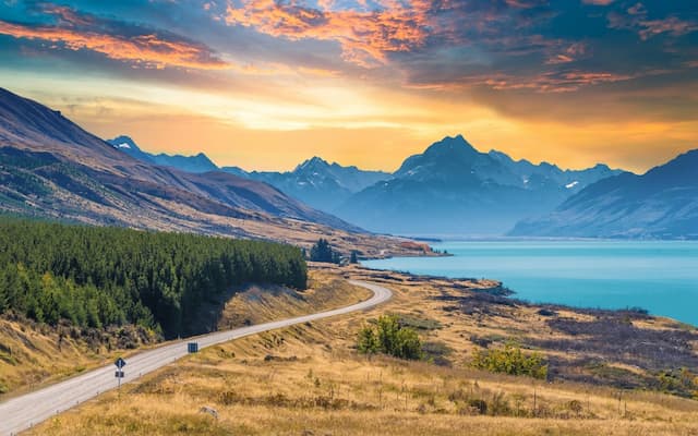
Geography in New Zealand
Our area on the limit of the Pacific and Indo-Australian structural plates has molded our landforms. The subsequent earth developments have created bumpy and precipitous territory more than 66% of the land, with visit seismic tremors in many pieces of the nation and a zone of volcanic and geothermal movement in the focal North Island (Ministry for the Environment, 1997).
The collision of two plates has built two major islands those together exhibit active volcanoes and fault systems, and these geologic features are very evident in the topographic pattern.

Top tour packages
 10 Nights / 11 Days
Experience New Zealand
Auckland (1N) Rotorua (2N), +4 more
Internal Flight Included
₹2,76,540
per person
- Sep
 10 Nights / 11 Days
Experience New Zealand
Auckland (1N) Rotorua (2N), +4 more
Internal Flight Included
₹2,76,540
per person
- Oct
9 Nights / 10 DaysNew Zealand Discovery Tour
Auckland (2N) Rotorua (2N), +3 more
Main + Internal Flight Included
₹3,33,440
per person
- Aug
 9 Nights / 10 Days
New Zealand Discovery
Auckland (2N) Rotorua (2N), +3 more
Main + Internal Flight Included
₹3,69,820
per person
- Nov
 11 Nights / 12 Days
Experience New Zealand
Auckland (1N) Rotorua (3N), +4 more
Main + Internal Flight Included
₹4,52,850
per person
- Nov
 11 Nights / 12 Days
Experience New Zealand With FJ Chef Tour
Auckland (2N) Rotorua (2N), +4 more
Main + Internal Flight Included
₹4,75,510
per person
- Nov
 11 Nights / 12 Days
Experience New Zealand With Chef
Auckland (2N) Rotorua (2N), +3 more
Main + Internal Flight Included
₹5,00,340
per person
- Nov
 11 Nights / 12 Days
Experience New Zealand With Chef
Auckland (1N) Rotorua (3N), +4 more
Main + Internal Flight Included
₹5,08,720
per person
- Nov
 18 Nights / 19 Days
Naturally New Zealand With Amazing Australia
Auckland (1N) Rotorua (2N), +7 more
Internal Flight Included
₹5,57,440
per person
- Oct
 18 Nights / 19 Days
Experience New Zealand with Australia
Auckland (1N) Rotorua (2N), +7 more
Main + Internal Flight Included
₹6,36,250
per person
- Sep
 18 Nights / 19 Days
Experience New Zealand with Australia
Auckland (1N) Rotorua (2N), +7 more
Main + Internal Flight Included
₹6,46,380
per person
- Oct
 17 Nights / 18 Days
Experience Australia & New Zealand Ex Bom - Return Bom
Sydney (3N) Cairns (2N), +6 more
Main + Internal Flight Included
₹6,66,440
per person
- Nov
17 Nights / 18 DaysExperience Australia & New Zealand Ex BOM - Return AMD
Sydney (3N) Cairns (2N), +6 more
Main + Internal Flight Included
₹6,68,440
per person
- Nov
 17 Nights / 18 Days
Experience New Zealand & Australia With Tranzalpine Train With Chef
Auckland (1N) Rotorua (2N), +7 more
Main + Internal Flight Included
₹7,11,330
per person
- Nov
18 Nights / 19 DaysExperience Australia And New Zealand
Melbourne (3N) Cairns (2N), +7 more
Main + Internal Flight Included
₹7,35,710
per person
- Dec
 13 Nights / 14 Days
New Zealand Winter Super Saver
Auckland (1N) Rotorua (2N), +5 more
Flight Not Included
₹1,74,530
per person
- Valid upto 30 Sep 2027
 12 Nights / 13 Days
New Zealand With Paihia Self Drive
Auckland (1N) Paihia (2N), +5 more
Main Flight Included
₹3,04,450
per person
- Valid upto 30 Sep 2027
 14 Nights / 15 Days
Honeymoon In New Zealand - Self Drive Tour
Auckland (2N) Tairua (1N), +6 more
Flight Not Included
₹2,01,740
per person
- Valid upto 30 Sep 2027
 13 Nights / 14 Days
Fascinating Fiji With New Zealand
Auckland (2N) Rotorua (2N), +4 more
Flight Not Included
₹2,00,120
per person
- Valid upto 30 Sep 2027
 12 Nights / 13 Days
New Zealand With Coromandel Self Drive
Auckland (1N) Whitianga (2N), +6 more
Flight Not Included
₹1,64,590
per person
- Valid upto 30 Sep 2027
9 Nights / 10 DaysNaturally New Zealand - Self Drive
Auckland (1N) Rotorua (2N), +4 more
Flight Not Included
₹1,25,930
per person
- Valid upto 30 Sep 2027
12 Nights / 13 DaysNew Zealand With Paihia Private Tour
Auckland (1N) Paihia (2N), +5 more
Flight Not Included
₹2,71,460
per person
- Valid upto 30 Sep 2027
 14 Nights / 15 Days
Naturally New Zealand With Beautiful Bora Bora Self Drive
Auckland (1N) Rotorua (3N), +6 more
Flight Not Included
₹3,30,790
per person
- Valid upto 30 Sep 2027
 9 Nights / 10 Days
Naturally New Zealand Private Tour
Auckland (1N) Rotorua (2N), +4 more
Flight Not Included
₹1,97,320
per person
- Valid upto 30 Sep 2027
22 Nights / 23 DaysNaturally New Zealand With Pure Pods Private
Auckland (1N) Paihia (2N), +10 more
Flight Not Included
₹4,53,130
per person
- Valid upto 30 Sep 2027
22 Nights / 23 DaysNaturally New Zealand With Pure Pods Self Drive
Auckland (1N) Paihia (2N), +10 more
Flight Not Included
₹2,92,690
per person
- Valid upto 30 Sep 2027
 16 Nights / 17 Days
Naturally New Zealand With Tauranga New Zealand Self Drive Tour
Auckland (1N) Tauranga (2N), +8 more
Flight Not Included
₹1,99,390
per person
- Valid upto 30 Sep 2027
 16 Nights / 17 Days
Naturally New Zealand With Tauranga New Zealand Private Tour
Auckland (1N) Tauranga (2N), +8 more
Flight Not Included
₹3,17,710
per person
- Valid upto 30 Sep 2027
 19 Nights / 20 Days
Naturally New Zealand With Tongariro National Park Self Drive Tour
Auckland (2N) Rotorua (2N), +9 more
Flight Not Included
₹2,28,550
per person
- Valid upto 30 Sep 2027
 19 Nights / 20 Days
Naturally New Zealand With Tongariro National Park Private tour
Auckland (2N) Rotorua (2N), +9 more
Flight Not Included
₹3,68,110
per person
- Valid upto 30 Sep 2027
 21 Nights / 22 Days
New Zealand Explorer Self Drive Tour
Auckland (1N) Paihia (2N), +10 more
Flight Not Included
₹2,71,740
per person
- Valid upto 30 Sep 2027
14 Nights / 15 DaysNaturally New Zealand With Interislander Ferry
Auckland (2N) Rotorua (2N), +7 more
Flight Not Included
₹2,99,220
per person
- Valid upto 30 Sep 2027
 16 Nights / 17 Days
Spectacular South Island Self Drive Tour
Christchurch (2N) Kaikoura (1N), +9 more
Flight Not Included
₹2,03,800
per person
- Valid upto 30 Sep 2027
 12 Nights / 13 Days
New Zealand With Coromandel Private Tour
Auckland (1N) Whitianga (2N), +6 more
Flight Not Included
₹2,71,460
per person
- Valid upto 30 Sep 2027
 13 Nights / 14 Days
Scenic South Island With North Island Private Tour
Christchurch (1N) Lake Tekapo (1N), +5 more
Flight Not Included
₹3,18,500
per person
- Valid upto 30 Sep 2027
 14 Nights / 15 Days
Naturally New Zealand With Interislander Ferry - Self Drive
Auckland (2N) Rotorua (2N), +7 more
Flight Not Included
₹1,86,210
per person
- Valid upto 30 Sep 2027
13 Nights / 14 DaysScenic South Island With North Island Self Drive Tour
Christchurch (1N) Lake Tekapo (1N), +5 more
Flight Not Included
₹2,00,840
per person
- Valid upto 30 Sep 2027
 14 Nights / 15 Days
Honeymoon In New Zealand - Private Tour
Auckland (2N) Tairua (1N), +6 more
Flight Not Included
₹3,06,370
per person
- Valid upto 30 Sep 2027
Happy Travellers
Memorable Spain And Portugal Journey with Flamingo
MS.Shilpa Parikh
 Jul
JulAmazing USA West Coast Journey with Flamingo
MR.Atul Patt
 May
MayMemorable Dubai Tour Experience
MR.Nitin Jariwala
 Dec
DecMemorable Spain And Portugal Tour with Flamingo Travels
MR. Bharat Patel
 Apr
AprGreat And Wonderful Vacation with Flamingo Travels
MR .Govind Patel
 Apr
AprMemorable Spain And Portugal Vacation with Flamingo
MR. Jagdish Patel
 Apr
AprWonderful Spain And Portugal Trip with Perfect Planning And Execution
MR. Kaushik Patel
 Apr
AprIncredible Spain And Portugal Journey with Wonderful Memories
MR. Virendra Patel
 Apr
AprAmazing Spain And Portugal Tour Experience with Flamingo Travels
MR. Pankaj Patel
 Apr
AprKnowledgeable Caring Tour Manager With Flamingo Travels
MR. Rohit Patel
 Apr
AprTrending travel articles

Affordable Bali Trip Under ₹30000 – Flamingo Transworld Budget Itinerary for First-Time Travelers
Summary: Looking for a budget-friendly Bali trip in 2026? This blog shows how you can enjoy a relaxing 5-day Bali Trip under ?30000/- by choosing smart stays, simple food and the right places. Perfect for first-time Indian travellers looking for a budget-friendly Bali holiday. We all have seen tons of pics of temples, Bali Swing, […]

Japan Tour Packages from India Under ₹3 Lakh – Explore Japan on a Budget
Summary: Your dream of exploring Japan is possible, even with a strict budget! This blog shares how Japan tour packages from India under ?3 lakh are possible. It covers real costs, budget tips, the best time to visit, and much more. It helps you understand how to save money and still enjoy a great Japan […]
Singapore Tour Packages from India Under ₹1 Lakh – Budget-Friendly Trips 2025-26
Summary: A trip to Singapore can fit your budget with the right plan. This blog explains how Singapore tour packages from India under ?1 lakh work, what costs to expect, and how to save money. It helps you understand the best places to visit in Singapore in 2026 so you can enjoy this island country […]

Top Indian Restaurants in Hanoi to Try in 2026!
Summary: Indian restaurants in Hanoi are more than just places to eat. They serve Indian food with a Vietnamese welcome. Whether you are a vegetarian, prefer halal food, or just miss home-style dal, these restaurants have it all. Every meal is served with care and a friendly smile, making you feel right at home in […]

Macau – A city that refuses to sleep , and wont let you either !
Summary: Macau Travel – Macau is a city that never slows down—filled with luxury hotels, thrilling attractions, endless nightlife, and unforgettable energy. From staying at The Venetian to breathtaking Macau Tower views and vibrant casinos, Muskan Golecha’s experience captures the true spirit of a city that you don’t just visit, you live! Macau is one […]

10 Days Itinerary for Switzerland – Perfect Trip Plan for First-Time Visitors!
Summary: If you want a calm, scenic, and well-paced trip, this 10 days itinerary for Switzerland is made for you. It suits families, honeymooners, seniors, and solo travellers. This plan combines top attractions with relaxed, easy travel days. It also keeps Indian comfort in mind. Read on to get the full day-by-day plan, smart tips, […]

Switzerland in Winter 2026: A Fairytale Experience of Snow, Alps & Christmas Markets!
Summary: Switzerland in winter 2026 is pure magic, snow-dusted Alps, glittering Christmas markets, and cozy wooden chalets bring fairytales to life. Whether you are sipping hot chocolate by the beautiful Swiss lakes or exploring the festive streets of cities, it feels like a movie. Perfect for Indian travellers, families, and honeymooners. This blog helps you […]

Christmas in Dubai 2025: Lights, Luxury & Festive Shopping!
Summary: Experience the magic of Christmas in Dubai 2025, where the city sparkles with lights, music, and festive cheer. From grand events to lively markets and fireworks, every corner feels joyful. Enjoy delicious food, family fun, and exciting shopping deals during the Dubai festive season. Plan your trip easily with Dubai Tour Packages and make […]

Bhutan In December 2025- Weather, Insider Tips, Best Time to Visit, and Things to Do!
Summary: Experience the magic of a trip to Bhutan in December 2025, with clear skies, vibrant festivals, fewer crowds, and stunning mountain views. This blog guides you through weather updates, travel tips, places to visit, and must-try experiences for your perfect Bhutan holiday. Plan your relaxing, crowd-free visit to Bhutan and experience the authentic charm […]

How to Plan A Budget Trip To Vietnam Under ₹60,000!
Summary: Trip To Vietnam Under ?60000 – Dreaming of travelling to Vietnam without stretching your wallet? This blog shares how to plan your trip to Vietnam under ?60,000. It shares everything, including flights, hotels, meals, and activities. Discover must-visit cities, real cost breakdown, and much more to make your Vietnam tour package memorable yet budget-friendly. […]